WIDMO Spectral Technologies (formerly SGPR.tech) solution now commercially available
Warning: Undefined array key "juiz_sps_order" in /home/users/innoventure/public_html/innoventure.vc/wp-content/plugins/juiz-social-post-sharer/inc/front/buttons.php on line 302
Aug. 7th, 2022
 SGPR.Tech was established in 2019 by the INNOventure fund and a group of specialists in radio wave propagation and geological technologies – prof Andrzej Kułak (AGH University of Science and Technology), prof Cezary Worek (AGH University of Science and Technology), Jerzy Kubisz (Jagiellonian Unversity), Mirosław Trześniowski (KGHM, PwC), Tomasz Trześniowski (PwC). Its goal was to develop and commercialize broadband GPR technology.. Their innovative frequency modulation technology allows for fast and accurate mapping of subsurface structures, deeper wave penetration, and energy savings. In the following years, the project raised further rounds of funding: from the EIT Raw Materials Start-up & SME Booster Program, the National Center for Research and Development, a grant from the European Commission, and from a group of business angels.
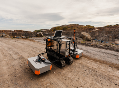
Now the company, under its new name, WIDMO Spectral Technologies, offers its technology to customers as a service. The basic package includes: 6 echograms for each route (LMH, LM, MH, L, M, H), routes maps, a document explaining the difference between echograms in different frequency ranges, electronic information delivery. Extended package also includes marking of the geophysical anomalies on the echogram (2D). The most comprehensive package includes further elements: 3D model, interpretation linked to borehole data, individual queries valued separately (e.g. estimation of overburden, layer pull, estimation of the volume of deposits, determination of the bottom of the deposit, differentiation of sand in clay or clay in sands).
The capabilities of the system include:
– lithological interpretation between documentation points (e.g. holes, probings, shurfs, trenches etc.),
– soil type recognition (granulometry),
– recognizing the type of rocks (gypsum, salts, coals),
– recognition of anthropogenic soils,
– recognition of karst areas (karst hazards),
– determination of the depth and thickness of layers (impermeable layers, deposits, concrete layers),
– determination of the groundwater level,
– identification of piles,
– infrastructure identification (pipes, cables, steel anchors, diaphragm walls, bars, DSMs etc.),
– recognition of the structure (nature) of waste in landfills.
Upcoming capabilities:
– mining damage recognition,
– assessment of the extent of the rock and soil weathering zone and the thickness of weathering,
– analysis of groundwater flow directions (potential difference),
– identification of soil or water pollution with oil derivatives or other means,
– recognition of reinforcement in concrete,
– sapper reconnaissance of the construction site.